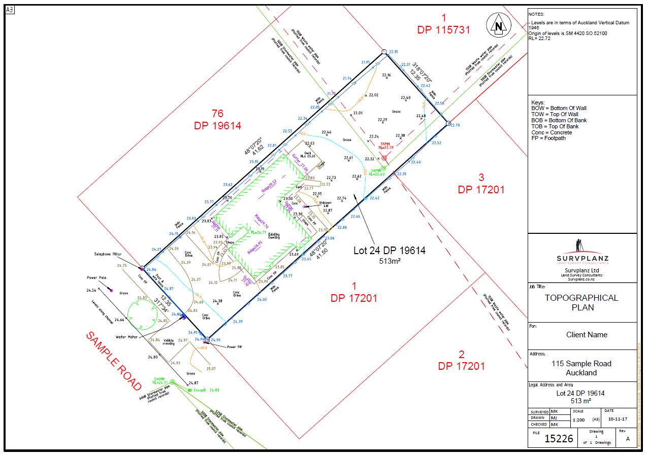
For the successful design and construction of any structure, having an accurate understanding of the land’s details is crucial. This is where a topographic survey, also known as a site survey, comes into play. It provides an exact representation of the ground’s attributes, encompassing natural features and man-made elements like buildings, fences, trees, land contours, vegetation zones, utility setups, and more. Whether you are constructing a house, dealing with a big subdivision, or infrastructure, you need a reliable topographical survey.
Typically, a PDF plan is generated as part of topographic surveys, while the 3D electronic data aids in calculating earthwork volumes and designing various elements such as structures, dwellings, driveways, and drainage systems.
Engineers and architects rely on this plan for improving the site architecture. Furthermore, there are instances where local Council authorities require a topographic survey to ensure the construction project aligns with the standard building regulations.
At this stage, our team can assist you with the preparation of survey plans and other necessary legal documentation required by your local Council.
We perform a comprehensive site survey before construction to measure ground contours and document site elements like neighbouring buildings, trees, fences, spot heights, public drainage services and the boundary with occupations.
Equipped with cutting-edge survey equipment and software, our team of licensed cadastral surveyors creates high-quality topographic maps or topo survey plans for your land. These plans become valuable resources for you, your architects, and your engineers to accurately design your build project.
We provide a competitive price for our topographical surveys or other land survey services, along with the quickest field survey time. Within a few days, we’ll share the final plan with you.
Ready to move forward? Simply complete our “Request A Quote” form on this page by providing the necessary details about your project.
While the specifics of each topographic survey plan can vary based on project demands, our standard plan encompasses the following details:
If your architect or engineer requires extra survey information, please don’t hesitate to inform us.
To get started, simply fill out the “Request a Quote” form on this page, explaining your specific requirements. Using various tools, we’ll gather the necessary survey information. Additionally, we’ll utilise resources like Google Earth and Google Street View to thoroughly visualise your site.
Once we’ve collected the essential data, we’ll promptly provide you with a detailed fee proposal. Based on this proposal, you will decide if you want to move forward with us. If you want to proceed with the next steps, we’ll present you with an engagement form for your approval.
Once confirmed, we’ll coordinate the fieldwork date according to our agreed schedule. On the scheduled date, our licensed cadastral surveyors visit your site and carry out the necessary fieldwork. After a few days, we will process your topographic survey plan and share it with you.
To receive our fee proposal tailored to your project, kindly complete the “Request a Quote” form on this page. We’re eager to lend our support!
You’ll need a topographical survey when designing buildings or infrastructure, subdividing land, analysing site suitability, ensuring zoning compliance, planning landscaping, assessing environmental impact, resolving property disputes, or maintaining infrastructure. It provides essential information about the land’s features and contours for informed decision-making. A topo survey is also used by a number of other disciplines such as geotechnical investigations, infrastructure design, ecological reports, archaeological reports, architectural design and landscaping reports.
How much does a topographical survey cost?The cost of a topographical survey varies based on the available survey information, the land size, the slope and the extent of vegetation in the land, and more. For an exact estimate, you can visit our pricing page and see our pricing table to calculate the price according to your site requirements.
Can you provide a previous sample of the topographical survey plan?Absolutely. You can see a sample of our previous survey plan at the top of this page.
What is the turnaround time to do a topographical survey?Typically, fieldwork for normal site surveys is completed within 1 to 2 days and the survey report is created afterwards. We employ high-quality, modern equipment to enhance both speed and accuracy.
My architect needs a DWG file and Tin tile, can you provide it?Yes definitely. We’ll send you both a PDF file and a DWG file that’s compatible with ACAD 2000 and above. If needed, we can share ACAD 3d or Tin file at no additional cost, especially if your architect requires it.
Do we need to stay at home during the topographic survey?Not at all necessary. You don’t have to be at home during the survey. Our work takes place outside the building, so your presence isn’t required. However, if there are gates to unlock or if you have dogs that need to be controlled, we’ll need you to be present at the time of the survey.